Brief History of Mercer County
In 1836, the settlers in this area, particularly those along the Flat Top Mountain, Bluestone River and Brush Creek, feeling themselves greatly inconvenienced by the distance they had to travel to their county seat in Pearisburg, Virginia, determined to have 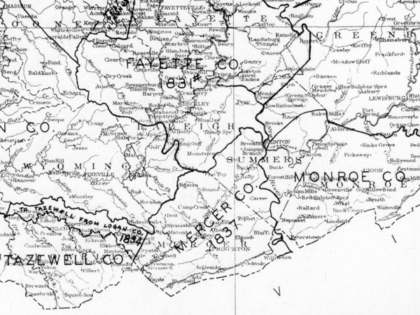 a new county, and so petitioned the General Assembly of Virginia. Many of these petitioners were owners of large tracts of land, and the goal they sought, no doubt, had a significant influence upon the future growth and development of this area.
Supported by the petition, a bill was introduced into the Virginia Assembly by Giles County representative Daniel Hale, and on March 17, 1837, the General Assembly of Virginia passed the Act creating Mercer County from parts of Giles and Tazewell counties ( see Exhibit 1 ). Since its creation in 1837, the original boundary lines have been altered three times, the most significant change being made on February 27, 1871 by the Act creating Summers County ( see Courthouse Controversy ).
The new county was named Mercer County in memory of General Hugh Mercer, who was mortally wounded on January 3, 1877 during the Revolutionary War at the Battle of Princeton in New Jersey. According to Kyle McCormick in his book The Story of Mercer County, it was not known just why Mercer was selected as the name of the new county other than possibly that the Mercer family was influential in eastern Virginia. He practiced medicine and operated an apothecary shop in Fredericksburg, Virginia, where, also, an impressive monument has been erected in his memory.
Commissioners were appointed to locate a place upon which to erect the courthouse for the new county, and they decided on a location where the present Courthouse now stands. The question of the name for the new county seat was debated, and it was finally decided that the name Princeton, where General Mercer fell mortally wounded, was sufficiently appropriate.
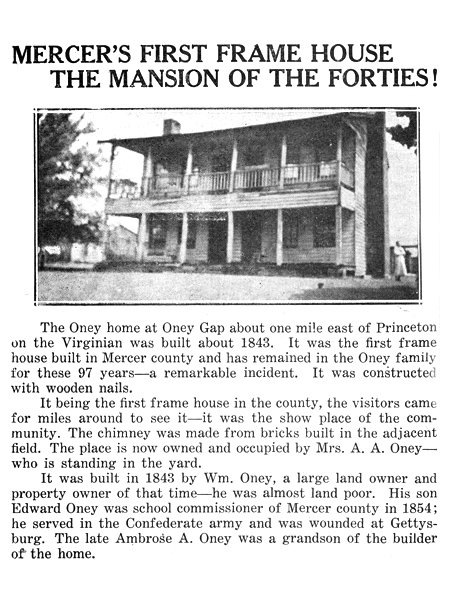
At the time of its formation, Mercer County was a vast underdeveloped wilderness. Some people referred to it informally as being the “wilderness county”. All of the buildings throughout the county were of the log type until William Oney, a large property owner, built the first frame house in Mercer County in 1843 at Oney Gap about one mile east of Princeton. Scattered throughout this area of virgin timber were fewer than a dozen settlements connected by trails and hazardous mountain roads. One of the sparse settlements that would eventually emerge was in the area that is now Athens.
Exhibits
Exhibit 1: Act Creating Mercer County on March 17, 1837
“Be it enacted by the general assembly, That all that part of the counties of Giles and Tazewell, contained within the following boundary lines, to wit: Beginning at the mouth of East river in Giles county, and following the meanders thereof up to Toney’s mill dam; thence, along the top of said mountain to a point opposite the upper end of the old plantation of Jesse Belcher, deceased; thence, a straight line to Peerie’s mill dam, near the mouth of Alphs valley; thence to a point well known by the name of the Pealed Chestnuts; thence, to the top of the Flat Top mountain; thence along said mountain, with the lines of Logan, Fayette and Tazewell counties, to New river; thence, up and along the various meanderings of the same to the beginning, shall form one district and new county, and be called and known by the name of Mercer county, in memory of General Hugh Mercer who fell at Princeton.” (Source: Making A State, by Edgar B. Sims)
Exhibit 2: William Oney House, the first frame house in Mercer County, documented in the Princeton Observer, August 5, 1937.